|
|
|
Advertisements:
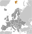
GeographyLocation
Northern Europe, islands between the Arctic Ocean, Barents Sea, Greenland Sea, and Norwegian Sea, north of Norway Geographic coordinates
78 00 N, 20 00 E
Map references
Europe
Area World Ranking: 125
Total 62,045 sq km
Land 62,045 sq km Water 0 sq km Note Includes Spitsbergen and Bjornoya (Bear Island) Area - comparative
Slightly smaller than West Virginia Land boundaries
0 km
Coastline
3,587 km
Maritime claims
Territorial sea 4 nm
Exclusive fishing zone 200 nm unilaterally claimed by Norway but not recognized by Russia Climate
Arctic, tempered by warm North Atlantic Current; cool summers, cold winters; North Atlantic Current flows along west and north coasts of Spitsbergen, keeping water open and navigable most of the year Terrain
Wild, rugged mountains; much of high land ice covered; west coast clear of ice about one-half of the year; fjords along west and north coasts Elevation extremes
Lowest point Arctic Ocean 0 m
Highest point Newtontoppen 1,717 m Natural resources
Coal, iron ore, copper, zinc, phosphate, wildlife, fish Land use
Arable land 0%
Permanent crops 0% Other 100% (no trees; the only bushes are crowberry and cloudberry) (2005) Irrigated land
NA
Natural hazards
Ice floes often block the entrance to Bellsund (a transit point for coal export) on the west coast and occasionally make parts of the northeastern coast inaccessible to maritime traffic Environment - current issues
NA
Geography - note
Northernmost part of the Kingdom of Norway; consists of nine main islands; glaciers and snowfields cover 60% of the total area; Spitsbergen Island is the site of the Svalbard Global Seed Vault, a seed repository established by the Global Crop Diversity Trust and the Norwegian Government
Comments
Add a new comment: |
Advertisement
Members area
Svalbard [ Norway ] (Norway):
 
GPS points from Svalbard [ Norway ] (Norway)
|
||||||||

 First discovered by the Norwegians in the 12th century, the islands served as an international whaling base during the 17th and 18th centuries. Norway's sovereignty was recognized in 1920; five years later it officially took over the territory.